Atyrau Oil & Gas
On the Effectiveness of «Direct» Methods of Hydrocarbon Exploration
Pavel Ivashchenko, General Director of IGS Corporation,
Vladimir Geyenko, Vice President of IGS Corporation,
Yevhen Pushchyk, Director of Development and Communications of IGS Corporation
It is well known that the profitability of oil and gas producing companies directly depends on the efficiency of exploration methods.
Both «direct» and «indirect» exploration methods are currently used to explore for hydrocarbons. The difference between them is that indirect exploration methods study the physical properties of rocks and minerals in the Earth’s interior, while direct methods reveal the presence and composition of minerals in the survey areas.
Direct ground-based methods for studying geological objects include artificial workings, geological surveying and mapping, geochemical methods, ground and borehole NMR methods, as well as a number of other borehole research methods. Earth Remote Sensing methods are also used to remotely detect surface pinching out of minerals.
The leading, and often the main method of hydrocarbon exploration is seismic exploration. This method is related to indirect methods, since based on the results of measurement and interpretation of a complex of physical data, geological structures that are promising for filling with fluids are identified.
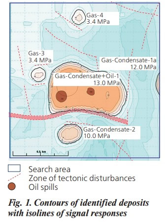 Fig. 1. Contours of identified deposits with isolines of signal responses
Despite significant scientific and technological advances in seismic exploration, this method has fundamental limitations and lacks efficiency in hydrocarbon exploration. Low success rates of onshore (average 30%) and offshore drilling (average 10%), lead to significant financial losses for companies drilling «dry» wells, as well as to low intensity of new deposits discovery.
In order to increase the efficiency of geological exploration, specialists from INNOVATIVE GEOPHYSICAL SERVICE CORPORATION, California, USA, have developed and successfully apply the following «direct» methods of geophysical exploration of hydrocarbons.
The first method, Geodirect RSS (RSS – Resonant Spectral Sensing), is intended for remote detection and delineation of deposits, as well as for their detailed examination.
The second method, Geodirect NMR (NMR – Nuclear Magnetic Resonance), provides the possibility of detailed examination of deposits directly on the ground.
Geodirect RSS/NMR methods have been successfully tested in the USA and other countries, and are used in countries of five continents for the search and exploration of hydrocarbons, solid minerals, artesian and thermal waters.
In 2019, the Geodirect RSS method was recognized in Europe as the best in searching for artesian waters and was awarded an honorary prize – «Crystal Drop of Water» .
More complete information about testing methods and work performed can be obtained on the company’s website: http://igs-service. tech, and in publications [1, 2, 3].
POSSIBILITIES AND FEATURES OF USING THE GEODIRECT RSS SERVICE
The method itself belongs to the class of emission methods of spectral analysis and consists of two sequential processes - resonant spectral processing of satellite images of the area taken in the IR range, then visualization and recording of the identified contours of oil, gas and gas condensate deposits on the map of the area.
The effectiveness of the Geodirect RSS method is characterized by the following indicators:
- The research area can be from minimal sizes (a well for examination) to tens of thousands of square kilometers,
- Research is carried out regardless of the time of year on geological structures of any complexity, on land and on the shelf;
- Research efficiency is close to 90%,
- Work is completed on average in two months;
- The work is absolutely environmentally friendly and confidential, its implementation does not require approval from local authorities.
Graphic results of the survey are plotted on a map of the site. As an example, in Fig. 1 shows a map of the Customer’s site with an area of 450 square km with the contours of identified hydrocarbon deposits. Graphic examples of the results of a detailed examination of identified deposits are shown in Figures 2-5.
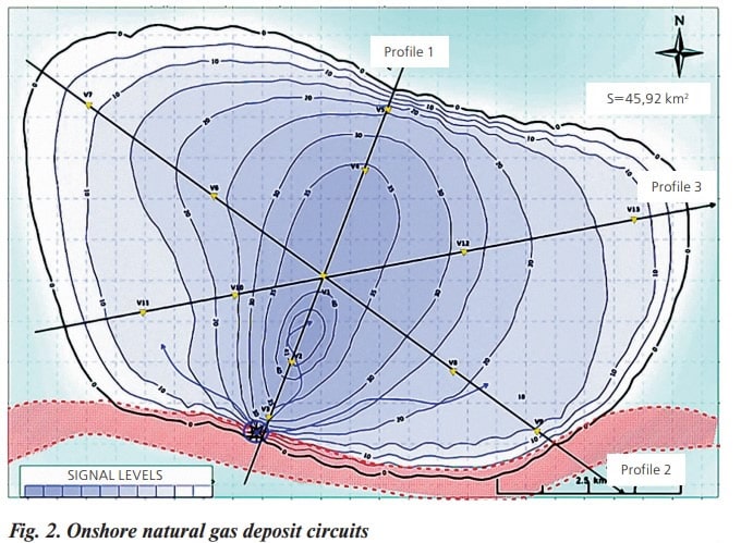 Fig. 2. Onshore natural gas deposit circuits
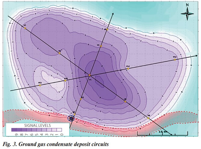 Fig. 3. Ground gas condensate deposit circuits
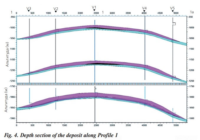 Fig. 4. Depth section of the deposit along Profile 1
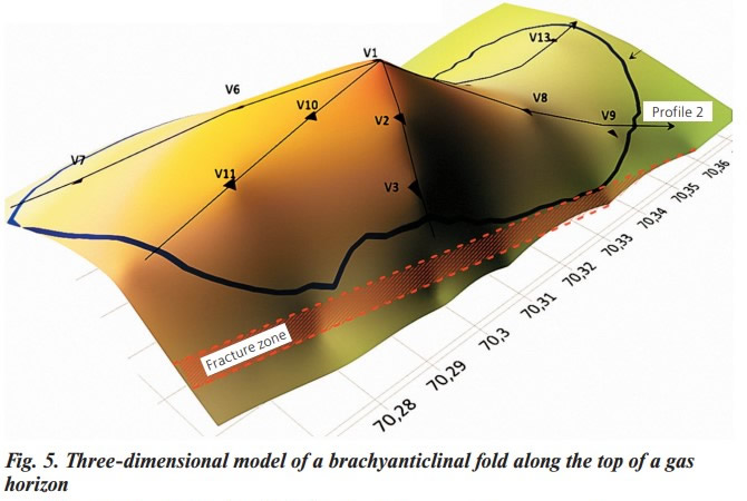 Fig. 5. Three-dimensional model of a brachyanticlinal fold along the top of a gas horizon
CAPABILITIES OF THE GEODIRECT RSS SERVICE FOR SURVEYING HYDROCARBON BASINS ON THE TERRITORY OF THE REPUBLIC OF KAZAKHSTAN
The geological structure of the subsoil of the Republic of Kazakhstan predetermined the presence of large hydrocarbon reserves located in various regions of the country. Some of these reserves are being successfully developed, but oil and gas exploration work over large areas requires large financial expenses and considerable time to complete.
Based on geological information, 15 sedimentary hydrocarbon basins have been identified on the territory of Kazakhstan, with total predicted resources of equivalent fuel of about 76 billion tons. Five of these basins are considered geologically promising, but remain poorly studied (green fields).
In this regard, our company proposes to use the progressive method of direct search and survey of hydrocarbon deposits GEODIRECT RSS on the territory of Kazakhstan, which will allow to successfully solve the following geological exploration tasks:
A) Survey area of several thousand square kilometers.
We perform an initial regional survey of the area to identify and delineate oil, gas and gas condensate deposits, and then perform a detailed survey of the largest deposits identified in the survey area.
As a result, we provide the Customer with the following data:
- Ground contours and areas of identified deposits,
- Isolines of signal responses for each type of hydrocarbons, Number of horizons, their thickness and depth;
- Presence of gas caps and gas pressure in them,
- Presence of watering of horizons;
- Depth sections of deposits,
- 3D models of horizon tires,
- Zones and optimal points for drilling wells,
- Calculation of predicted deposit resources. The overall effectiveness of research using the GEODIRECT RSS service is characterized by the following indicators: Survey depths reach 5-7 km,
- Duration of the examination and provision of results – up to two months,
- The success rate of well drilling according to the study results is 90%,
В) Survey area of several tens of thousands of square kilometers.
We get the results of survey of territories similar to the item A. However, the survey time increases up to 3 - 4 months depending on the total area of the survey.
C) Survey of individual sites and blocks.
We obtain similar results of works with their duration of 1-2 months. The cost of works depends on the given survey area, the interval of required survey depths and volumes of required data.
D) Study of structures identified by seismic surveys and assessment of prospects for drilling wells planned based on seismic survey data. The Сustomer receives data on the prospects for drilling wells and the onshore contours of the hydrocarbon deposit in the area of the drilling point. The duration of the work is 1-2 months.
INTERACTION OF THE GEODIRECT RSS SERVICE WITH SEISMIC EXPLORATION
Both of these approaches can coexist separately, fulfilling the Customer’s tasks within the scope and capabilities of their services. But the best option is combine them, as a result of which the advantages of both methods will be combined.
Possible options for combined use of the Geodirect RSS service and seismic exploration:
1. Study of structures identified by seismic surveys and assessment of prospects for drilling wells planned based on seismic survey data.
Benefit: Costs for drilling «empty» wells are reduced by 3 times.
2. Regional study of sites, blocks and basins.
Benefit: Financial and time costs for exploration of deposits are reduced several times. The profitability of companies increases proportionally.
3. Integration with seismic exploration to improve the efficiency of well drilling.
Benefit: The success rate of well drilling tends to 100%.
Thus, the use of the Geodirect RSS method allows you to increase the success rate of well drilling, reduce the time and financial costs for discovering new deposits and developing existing deposits.
In total, this makes it possible for oil and gas producing companies to significantly increase the profitability of their activities.
Publications
- Bakai E.A., Ivashchenko P.N.: «Innovative Technologies». Business Panorama № 3, Ukraine, 2012, 67 pages.
- Ivashchenko P.N., Naumenko V.M.: «Technology of direct geophysical research «Geodirect» – features and capabilities». VII International scientific-practical conference «Topical issues of science and practice» November 2-06, 2020, London, Great Britain.
- Ivashchenko P.N., Bakai E.A., and Yurchuk A.I.: «About the possibility of identification of hydrocarbon deposits with the help of NMR». Geoscientific Instrumentation. Methods and Data Systems, 5, 551–559, 2016. Find by link: http://www.geosci-instrum-method-datasyst.net/5/551/2016/gi-5-551-2016.pdf.


