Technology
Geological Risk Assessment for Successful Exploration with Petrel Exploration Geology Module
Sergey Tyatyushkin, Geologist, Schlumberger Information Solutions
Every oil company invests generously into Exploration to ensure its long-term success, since the existing fields will be depleted sooner or later.
The Petrel*Exploration Geology module provide the effective technology solutions for play chance mapping and prospect assessment. This module allows assessing the key parameters of exploration work uncertainty to include the interpretation results into the process of assessing the perspective development sites, to define the prospects within the scope of explored area as well as to get a probabilistic estimate of hydrocarbon areas and the volumes of oil in place.
Petrel Exploration Geology includes the rapid analysis algorithms: one-dimensional modelling of petroleum system, followed by three-dimensional modelling for the further full-scale dynamic modelling in PetroMod* (software for dynamic simulation of petroleum system processes). The module allows assessing the key parameters of uncertainty such as: reservoir and seal rock properties, trap formation and their integrity, source rock maturity, generation and migration of the hydrocarbons.
The risk map analysis is performed for further ranking of the license areas. The hydrocarbon volumes are calculated in the perspective areas and the key parameters of the uncertainty are determined, since they influence the volume appraisal. The probability of failing the site development is also taken into consideration. Algorithms of probabilistic assessment are efficient while working with various scopes of data - from the prospecting areas to the separate accumulations. All results of calculations are dynamically connected with basic data, therefore it is possible to see an actual assessment of the studied area at data expeditious updating at once.
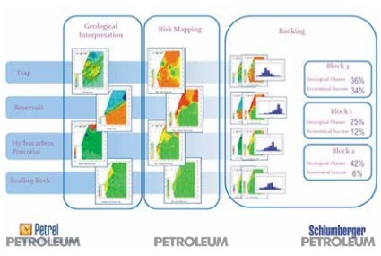
Each company uses its own methods for geological risks assessment during exploration works which can be implemented using the Petrel Exploration Geology module. General diagram is shown on the Figure 1.
*Schlumberger trademark
 Figure 1. General diagram for geological risk assessment and ranking of perspective license sites and areas.
It is known that the only way to avoid drilling a dry well is to refuse from drilling. Still, there are possibilities to increase the success of exploration drilling program with the help of geological risk assessment and analysis of oil and gas potential, with use of Petrel Exploration Geology module. There is an example of simple analysis, provided for South-Turgay basin.
Example of oil and gas content assessment for South-Turgay basin is made on the basis of published data.
The prospecting works began at South-Turgay basin relatively late- the first field (Kumkol) was discovered in 1984.
Practically all the terrigenous rocks, belonging to the suits from Jurassic and Lower Cretaceous systems, researched in different volumes, show the availability of the organic matter (OM) based on the laboratory researches, but many of them has too small concentration thereof. The OM content reaches 9.5%1 in the sediments of in Karagansay formation clays.
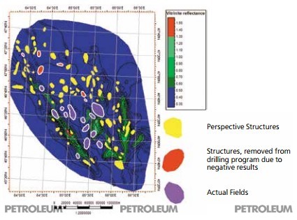
Several new fields are discovered over the last 10 years2. It means that this basin has still a good potential. Despite this, the dry exploration wells are still being drilled, which can cost millions of dollars for the companies. A schematic map of perspective structures, fields and abandoned sites due to the negative result3 is provided in the Figure 2.
![Figure 2. The schematic map of perspective structures, fields and abandoned sites due
to the negative result [2]](/imgdb/article_3/article_3_pre_680_2076.jpg) Figure 2. The schematic map of perspective structures, fields and abandoned sites due to the negative result [2]
Figure 2. The schematic map of perspective structures, fields and abandoned sites due to the negative result [2]
There are several structures on this map, which are removed from drilling program due to the negative results. There are large number of reasons, including geological and technological ones, explaining the lack of productivity at these structures. From the point of view of regional geology, these structures can turn to be dry because of lack of source rock maturity, since the basement is located rather high in these areas – please, see Figure 3. You can check this hypothesis using the Petrel Exploration Geology module. In this case only the Mesozoic1 bottom map is available in the literature, therefore, the modelling the source rock maturity was ensured for the most optimistic option, assuming that the source rock maturity is spread everywhere, being equally distributed over the Mesozoic bottom. The results of the source rock maturity modelling in Petrel Exploration Geology is shown in the Figure 4.
![Figure 3. Schematic Structural Map of Mesozoic Bottom [1]](/imgdb/article_3/article_3_pre_680_2077.jpg) Figure 3. Schematic Structural Map of Mesozoic Bottom [1]
Figure 3. Schematic Structural Map of Mesozoic Bottom [1] Figure 4. The greatest possible distribution of the source rock maturity zones-vitrinit’s reflecting properties
Conclusions
According to modelling results, it is clear enough that dry traps are located in the areas with lack of source rock maturity that can be an objective reason, leading to a negative result.
First of all, it is recommended to drill the structures in areas closer to cooked source rock.
The most perspective structures in South-East of South Turgay basin along the perimeter of Bozingen graben-syncline.
Even such an express assessment allows to drill more successful prospecting wells and to reduce the number of dry wells.
References
1. Deep structure and mineral resources of Kazakhstan. Oil and gas. Volume III, Almaty, 2002, p.248, authors: S.Zh. Daukeev, E.S.Votsalevskiy, D.A. Shlygin, V.M. Pilifosova, H.H. Paragulgova, V.P. Kolomiytsa, V.P. Komarova, ISBN 9965-13-760-9
2. Kazakhstan Today, www.kt.kz, "New fields are discovered in South-Turgai Oil Basin", 06.04.2011
3. Map of perspective oil and gas structures, scale of 1: 2 000 000, Information and Analytical Center of Geology and Mineral Resources of the Republic of Kazakhstan, www.infocenter.kz
Published the full text of the article


